History of some places in Puerto Rico
Puerto Rico is rich in history, culture, and natural beauty. Throughout the island, you'll find historic cities, ancient landmarks, and breathtaking natural wonders that tell the story of Puerto Rico's past.
From the centuries-old streets of Old San Juan and the impressive walls of El Morro Fortress to the lush landscapes of El Yunque National Forest, each destination offers a unique glimpse into the island's heritage. These places reflect the influences of the Indigenous Taíno people, Spanish colonization, and the vibrant culture that continues to shape Puerto Rico today.

Planning to visit Puerto Rico?
Puerto Rico is a destination filled with beautiful beaches, vibrant culture, amazing cuisine, and breathtaking natural landscapes. If you're thinking about traveling there, you'll find plenty of accommodation options for every taste and budget, from luxury hotels and beachfront resorts to cozy guesthouses and vacation rentals
Places to stay
-In San Juan, perfect for enjoying history, nightlife, and beautiful beaches.
-In Rincón, ideal for surfers and those seeking a more relaxed atmosphere.
-In Ponce, known for its rich culture and stunning architecture.
-In Fajardo, a great base for excursions and water activities.
Places to Visit
- Old San Juan
- El Yunque National Forest
- Mosquito Bay
- Flamenco Beach
- Castillo San Felipe del Morro
Puerto Rico has something for everyone! Whether you're looking for adventure, relaxation, or cultural experiences, you'll discover incredible places to stay and unforgettable attractions to explore during your trip. ✈️🌴☀️✨
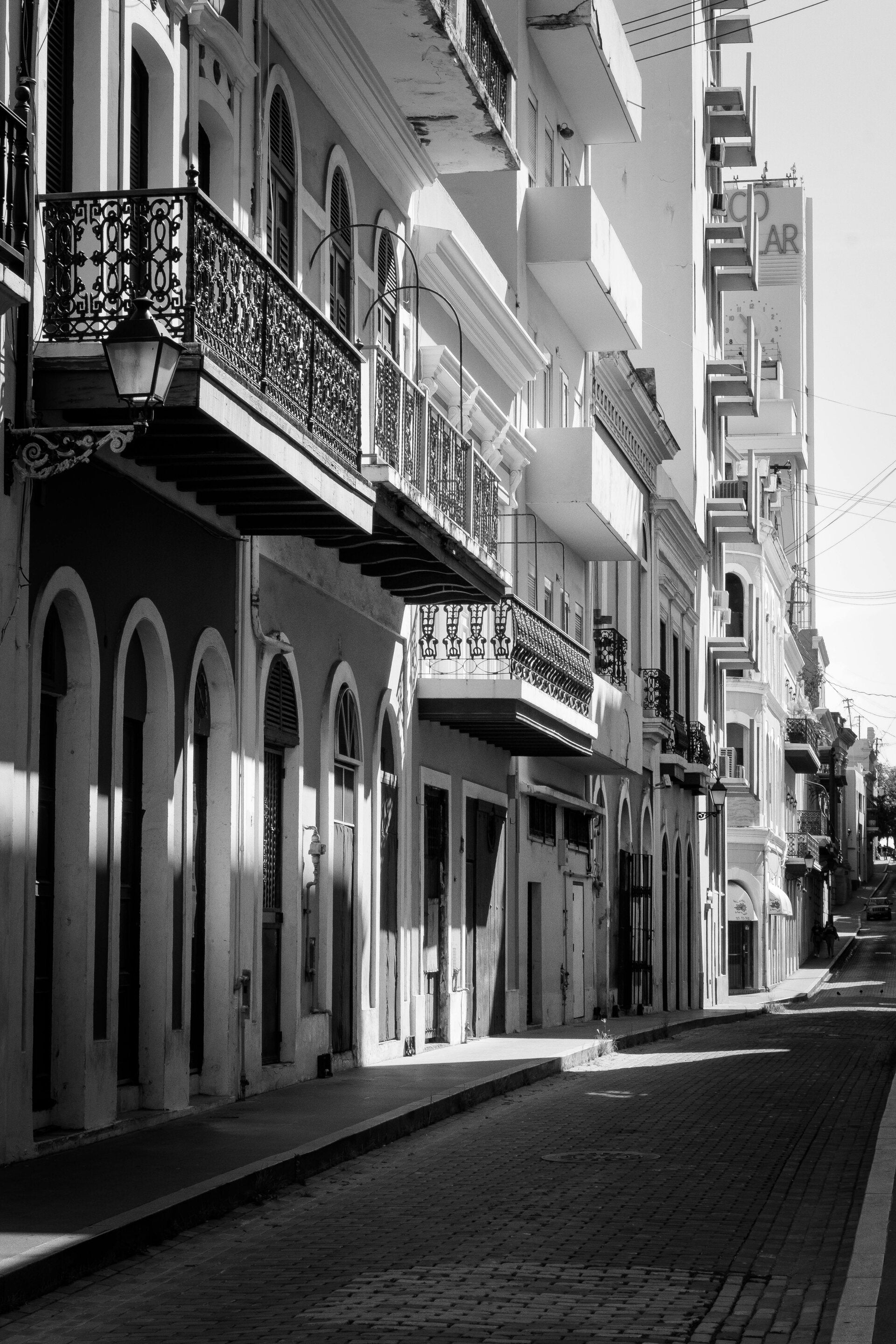
Old San Juan
Old San Juan is the historic district of San Juan, known for its colorful Spanish colonial architecture, cobblestone streets, and massive fortifications overlooking the Atlantic Ocean. As one of the oldest European-founded settlements in the Americas, it represents Puerto Rico’s cultural and architectural heritage and is a major tourist destination.
Key facts
-
Founded: 1521
-
UNESCO World Heritage Site: Designated in 1983
-
Notable landmarks: Castillo San Felipe del Morro, Castillo San Cristóbal
- Architectural style: Spanish colonial
-
Primary uses: Residential, commercial, cultural, and governmental
Historical background
Originally called “Puerto Rico,” the walled city of Old San Juan became Spain’s key Caribbean outpost in the 16th century. Its strategic harbor attracted traders and naval powers, prompting the construction of extensive defenses by Spanish engineers. These fortifications helped the city withstand attacks by English and Dutch forces during the colonial period.
Architecture and urban layout
The district preserves hundreds of pastel-colored masonry buildings, balconies, and plazas designed in classic Spanish colonial style. Narrow cobblestone streets made of blue ballast bricks from Spain wind through seven-square-block grids. Restoration efforts since the mid-20th century have emphasized conservation of both public monuments and private homes.
Cultural significance
Old San Juan remains a living neighborhood blending history and modern culture. It hosts museums, galleries, restaurants, and government offices, including the La Fortaleza—the oldest executive residence in continuous use in the Western Hemisphere. Festivals, music, and cuisine reflect the island’s blended Spanish, African, and Taíno influences.
Tourism and preservation
The area is one of Puerto Rico’s most visited attractions, drawing cruise passengers and heritage travelers alike. Managed jointly by the Puerto Rico Institute of Culture and the U.S. National Park Service, conservation programs maintain its historic integrity while accommodating local commerce and residents.

El Yunque National Forest
El Yunque National Forest is the only tropical rainforest within the U.S. National Forest System, located in northeastern Puerto Rico across the Sierra de Luquillo mountains. Covering nearly 29,000 acres, it is one of the smallest U.S. national forests but among the most biologically diverse, offering waterfalls, misty peaks, and a sanctuary for rare species.
Key facts
-
Location: Northeastern Puerto Rico (Río Grande and nearby municipalities)
-
Area: ~28,400 acres (11,300 hectares)
-
Established: 1876 (as a Spanish Crown reserve); U.S. designation in 1903
-
Elevation range: Sea level to 3,533 ft (1,077 m, Pico El Yunque)
-
Managed by: U.S. Forest Service
Natural Environment
El Yunque receives over 200 inches (5 meters) of rainfall annually, sustaining lush vegetation across four main forest types: Tabonuco, Palo Colorado, Sierra Palm, and Cloud Forest. The area’s rivers—such as the Mameyes, La Mina, and Icacos—provide water for nearly a fifth of Puerto Rico’s population. Its ecosystem hosts around 240 plant species, including 26 endemics, and endangered fauna like the Puerto Rican parrot, Elfin Woods Warbler, and Puerto Rican boa.
History and Cultural Significance
Originally protected by King Alfonso XII of Spain in 1876, El Yunque is among the Western Hemisphere’s oldest forest reserves. The Taíno people named it after the deity Yúcahu (or Yokahú), associated with mountains and fertility. Many of its historic structures—including the Mt. Britton Tower and Stone House—were built by the Civilian Conservation Corps during the 1930s, blending conservation with New Deal–era heritage.
Visitor Experience
El Yunque is about an hour’s drive from San Juan. Popular attractions include La Mina and La Coca waterfalls, Yokahú and Mt. Britton observation towers, and the El Portal Visitor Center. Visitors can explore roughly 25 miles (40 km) of trails ranging from paved strolls to steep climbs toward Pico El Yunque. Activities include hiking, birdwatching, ziplining, and guided ecological tours.
Conservation and Research
The forest is central to tropical research through the El Verde field station, part of the Luquillo Long-Term Ecological Research program. As a key wildlife corridor, El Yunque supports habitat restoration and climate studies, underscoring its role in global biodiversity conservation.
Uncover the fascinating history of Puerto Rico. Explore iconic landmarks, ancient fortresses, and stories that shaped the island. Journey through time and discover the historical treasures that await you.

Mosquito Bay
Mosquito Bay, also called Bahía Bioluminiscente, is a shallow lagoon on the southern coast of Vieques. It is world-renowned as the brightest bioluminescent bay on Earth, glowing vivid blue-green at night when the water is disturbed by paddles, fish, or waves.
Key facts
-
Location: South coast of Vieques, Puerto Rico
-
Organisms: Pyrodinium bahamense dinoflagellates
-
UN designation: U.S. National Natural Landmark
-
Brightness record: Guinness World Record (2008)
-
Access: Licensed kayak tours only
Natural phenomenon
The bay’s glow comes from microscopic plankton called dinoflagellates that emit light through a chemical reaction involving luciferin and luciferase. Movements in the water trigger bursts of luminescence, creating luminous trails around paddles and marine life. Concentrations exceed 700,000 organisms per gallon, intensified by the bay’s “S”-shaped mouth that restricts ocean exchange and by surrounding mangrove forests that supply organic nutrients.
Environment and conservation
Mosquito Bay’s ecosystem is protected by the Puerto Rico Department of Natural and Environmental Resources. To safeguard the fragile dinoflagellate population, visitors must join certified non-motorized tours; swimming, insect repellents, and flash photography are prohibited. After Hurricane María in 2017, the bay’s glow dimmed but rebounded stronger as mangroves and plankton populations recovered.
Visiting and best conditions
Tours depart from nearby Esperanza, with clear-bottom kayaks offering optimal viewing. The spectacle is brightest around the new moon, when minimal moonlight enhances contrast. Calm, cloudless nights further intensify the glow.
Cultural and scientific significance
The bay was named after “El Mosquito,” the ship of Puerto Rican pirate Roberto Cofresí. Beyond tourism, Mosquito Bay serves as a living laboratory for studying marine bioluminescence and ecological resilience. Its natural interplay of mangroves, calm tides, and dense plankton populations makes it a global benchmark for understanding and conserving bioluminescent environments.
ViequesIsland.com | Vieques Island Travel Guide | Ferries, Flights & Tips
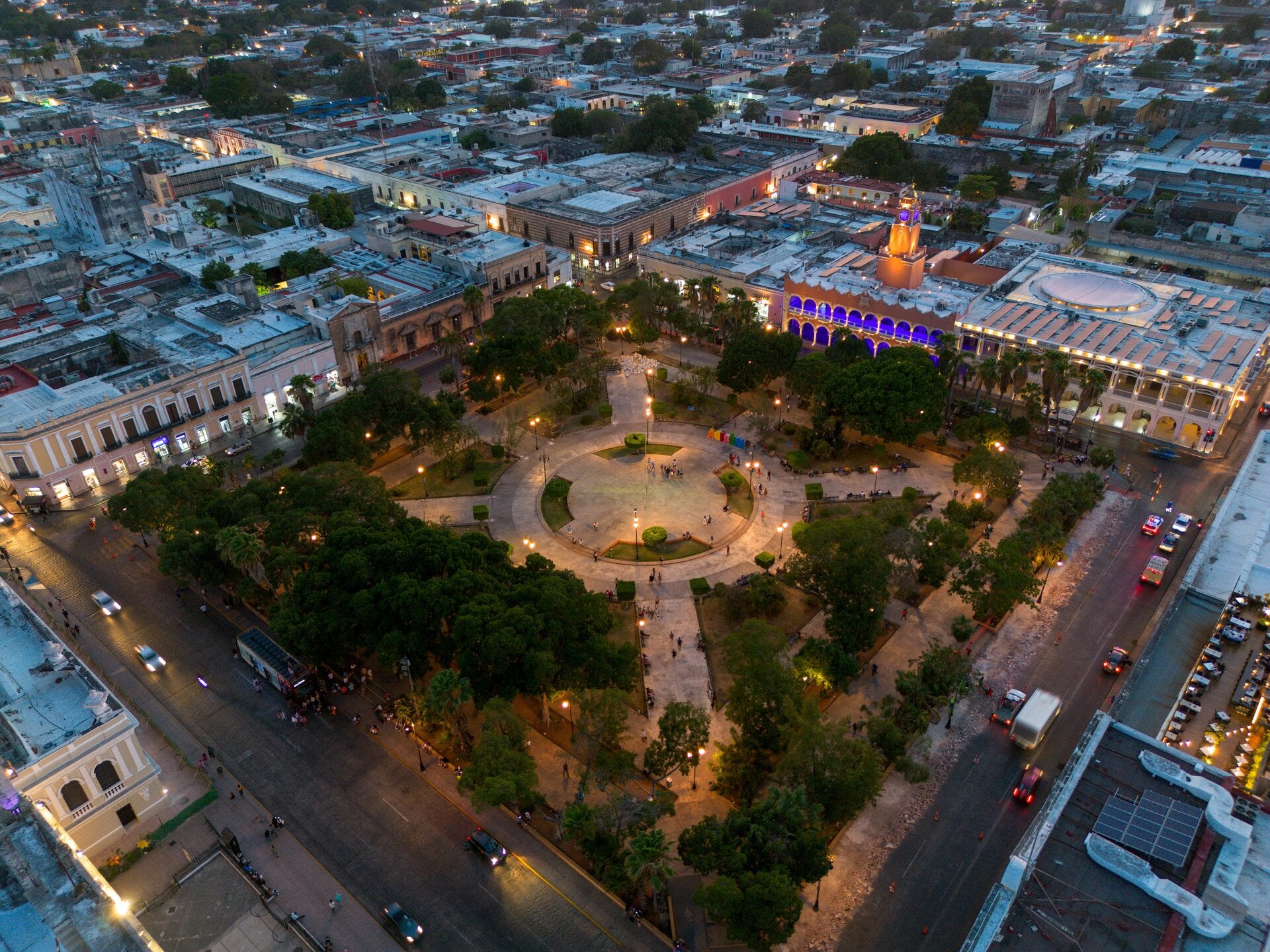
Ponce
Ponce is a city and municipality on the southern coast of Puerto Rico. Known as “La Perla del Sur” (The Pearl of the South), it is the island’s second-largest city and a major center of history, culture, and commerce in the Caribbean region.
Key facts
-
Founded: 1692 by Juan Ponce de León y Loayza
-
Population: ~137,000 (2020 census)
-
Region: Southern Puerto Rico, on the Caribbean Sea
-
Nicknames: “La Perla del Sur,” “Ciudad Señorial”
-
Government type: Autonomous municipality
History and development
Founded during the Spanish colonial era, Ponce rose to prominence in the 19th century as a hub for sugarcane, coffee, and shipping. Its downtown architecture—especially around Plaza Las Delicias—reflects neoclassical and Spanish colonial influences. The 1899 Ponce Massacre and the 1918 earthquake are pivotal events in its modern history.
Culture and architecture
Ponce is celebrated for its cultural vitality. Landmarks such as Parque de Bombas, a striking red-and-black former firehouse, and the Museo de Arte de Ponce, housing European and Caribbean art, symbolize its civic pride. The annual Carnaval de Ponce is one of the oldest in the Western Hemisphere, blending African, Spanish, and Puerto Rican traditions.
Economy and education
The city’s economy integrates tourism, healthcare, retail, and manufacturing. The Ponce Health Sciences University and several satellite campuses of the University of Puerto Rico reinforce its role as an educational hub. The Port of Ponce supports commercial and cruise traffic on the island’s south coast.
Geography and modern role
Ponce extends from the Caribbean shoreline inland to the central mountains, encompassing both coastal plains and foothills. It serves as the administrative and cultural capital of southern Puerto Rico and remains a key gateway for regional development and tourism.
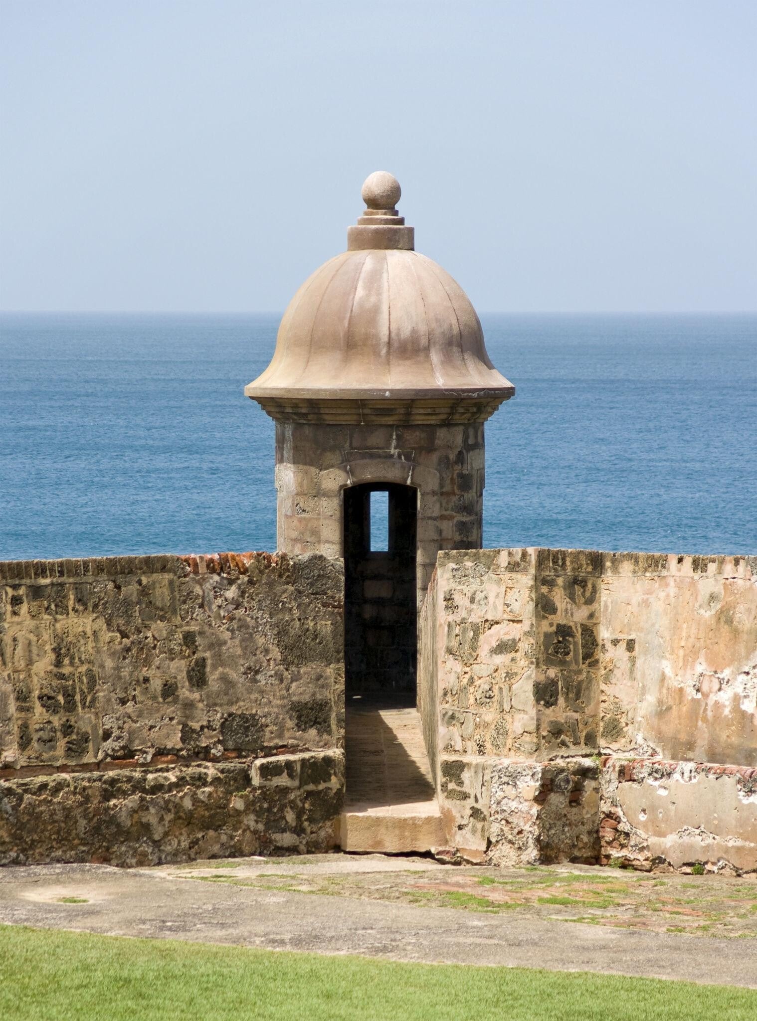
Castillo San Felipe del Morro
Castillo San Felipe del Morro, often called El Morro, is a 16th-century Spanish fortress overlooking the Atlantic Ocean at the entrance to San Juan Bay, Puerto Rico. Rising from the headland of Old San Juan, it symbolizes the island’s colonial heritage and centuries of maritime defense. Now part of the San Juan National Historic Site, it is a UNESCO World Heritage Site and one of the most visited landmarks in the Caribbean.
Key facts
-
Construction: Began 1539; completed c. 1790.
-
Levels: Six tiers of ramparts, tunnels, and barracks.
-
Height: ≈ 140 ft (43 m) above sea level.
-
UNESCO designation: 1983.
-
Managed by: U.S. National Park Service.
Origins and design
El Morro was conceived by Spanish engineers to guard the main Caribbean gateway to the Americas. Over 250 years of construction produced a masterpiece of colonial military architecture—massive stone bastions, dry moats, spiral ramps, and signature domed sentry boxes known as garitas. Its location allowed overlapping cannon fire with the smaller fort El Cañuelo across the bay, creating a deadly crossfire against enemy ships.
Military history
The fortress repelled attacks by English privateer Sir Francis Drake in 1595 and Dutch forces in 1625, falling only once when the Earl of Cumberland seized it briefly in 1598. It later endured the 1898 bombardment during the Spanish–American War, after which Puerto Rico passed from Spain to the United States. During both World Wars, U.S. forces installed observation bunkers and artillery control stations on its upper levels.
Architecture and features
Visitors explore six interconnected levels containing dungeons, barracks, storerooms, and a lighthouse dating to 1846 (rebuilt 1906). The fort’s thick masonry walls—up to 15 ft wide—rise above a vast grassy esplanade where locals now picnic and fly kites, transforming a onetime battlefield into a civic park. The site’s layered additions reveal the evolution of defense technology from cannon emplacements to 20th-century bunkers.
Visitor experience
Operated year-round by the National Park Service, El Morro opens daily (typically 9 a.m.–5 p.m.) with a $10 admission that also covers nearby Castillo de San Cristóbal. Exhibits, ranger talks, and panoramic ramparts attract travelers, families, and photographers alike. The climb rewards sweeping views of the Atlantic, San Juan Bay, and the pastel rooftops of Old San Juan—an enduring blend of history, wind, and sea